Sean Bagshaw Outdoor Exposure Photography

Images from the edge

See all image results...

Search Criteria
Exact matches only
Search in title
Search in content
Content Type
Select all
Search Posts
Search Prints & Stock Photos
Search Events
Search Pages
  • About
    • Sean’s Biography
    • A Look Through My Lens
    • Social Media
    • Alliances
    • Website Tour
    • Interviews And Podcasts
    • CV
  • Tutorials & TK Photoshop Plugins
  • Learn Nature Photography
  • Videos From My YouTube Channel
  • Signed Prints
    • Favorites Of 2023
    • OREGON
    • CANYONS AND RIVERS
    • CITYSCAPES
    • COASTAL
    • DESERTS AND PRAIRIES
    • FLOWERS AND PLANTS
    • FORESTS AND TREES
    • MOUNTAINS AND LAKES
    • NATIONAL PARKS
    • STREAMS AND WATERFALLS
  • PRINT OPTIONS
  • Stock Photography
    • OREGON
    • NORTH AMERICA
    • THE REST OF THE WORLD
    • AGRICULTURE AND VINEYARD
    • BUILT BY PEOPLE
    • NATURAL BEAUTY
    • OUTDOOR AND ADVENTURE
  • Books & Calendars
    • Calendars
    • Washington Evergreen
    • Oregon, My Oregon
    • Photographing Through The Seasons
  • Workshops
  • Events
  • Photography Blog
  • Sign Up For My Newsletter
  • Contact
  •  

Trip Report: Photographing Oregon's Owyhee Country

May 17, 2011 by Sean Bagshaw 6 Comments

Trip Report: Photographing Oregon's Owyhee Country

Malheur County may be one of the least known and least visited parts of Oregon. It is located in the extreme southeast corner of the state bordering Idaho and Nevada. Geographically it is one of the largest counties in Oregon with a total area of about 10,000 square miles, but it has one of the lowest population densities at just 3 people per square mile. Most of the population is centered around Ontario and Vale in the northern 15% of the county. Almost everything to the south is open range land managed by the BLM. There is just one paved road, Hwy 95, and one town, Jordan Valley.

But out in the arid scrub and ranch land of Malheur County lies the Owyhee River. The Owyhee drains a remote area of the high desert plateau on the northern boundary of the Great Basin and flows northward to the Snake River. The various arms and tributaries of the Oywhee cut deep canyons through the Owyhee Plateau, many with vertical rock walls that in places can be over 1,000 feet deep. 120 miles of the Owyhee River Canyon were designated as Wild and Scenic in 1984.

The southern reaches of the river can only be accessed by dirt roads, some fairly well maintained and others not more than jeep tracks. Even then there are just a handful of spots where it is possible to reach the river by vehicle. Most of the Owyhee and it’s tributaries can only be explored by backpacking or rafting.


People have been suggesting I check out the Owyhee country for years. As it is not along any usual route of travel and many hours from just about anywhere I had never visited this part of the state until this spring. I went to do some exploring and take some photos with fellow photographer, David Cobb, who had previously hiked and photographed portions of the river.

Finishing the morning shoot at the Cliffs of Rome.

I was absolutely drawn in by the beauty and scope of the canyons and the surrounding high desert. Along the drive south from Ontario the dirt road first takes you through Succor Creek Canyon which is just a small preview of what’s to come, but very scenic in its own right.

Succor Creek Canyon

Leslie Gulch is the main attraction along the Lake Owyhee reservoir and provides the easiest access to the river in this area. Throughout the gulch and all along Lake Owyhee the rock spires and escarpments are very reminiscent of Smith Rock State Park only, as David says, “on steroids”. We explored the main Leslie Gulch road and made a couple of forays up side canyons. The area to the north known as the Honeycombs looks particularly enticing but can only be reached by backpacking in or taking a boat over from the west side of the lake.

North of the town of Jordan Valley you can follow the Jordan Craters Road for about 30 miles into a large lava flow that originates at the Coffee Pot Crater.

Coffee Pot Crater

Spatter Cone at Jordan Craters
View from inside a spatter cone

Continuing on a side road from there you can wind your way down steep switchbacks and reach the river at the historic Birch Creek Ranch. This is one of the main takeouts for rafters floating the river.

Cliffs at Birch Creek Ranch
Birch Creek Ranch

Southwest of Jordan Valley is the community of Rome. Near Rome there are several dirt roads that offer access to the river canyon as well as the nearby Cliffs of Rome and Chalk Basin further to the north.

Pillars Of Rome

South of Hwy 95 between Rome and Jordan Valley, Three Forks road makes it’s way across about 30 miles of high desert to join the Owyhee River at Three Forks. David and I were glad to have my 4×4 for this road as we found it heavily rutted after winter rains. We also had to make about three creek crossings, the deepest of which engulfed my front bumper. From the map we saw that we could stop along the road a few miles north of Three Forks and hike out the the canyon rim. Photographing a roadless portion of the wild and scenic Owyhee at sunset sounded appealing, but after a few steps off the road we discovered ticks clinging to our pants. Despite giving David a serious case of the willies we continued on and were able to access a sweeping vista of the canyon before sundown. By the time we completed our hike back in the fading light we had found over 100 ticks between us! A strip search in the headlights revealed several more. I managed to find all of the ones on me, but David found several more lurking on him during the night and didn’t get a wink of sleep.

David trying to ignore the ticks

Three Forks is a popular put-in for rafters and the presence of hot springs make it an attraction for others as well. My main interest in returning to Three Forks is that this is where the adventurous backpacker can access the branching web of the upper Owyhee Canyon and it’s various tributaries. Radiating out from the Three Forks area are no less than six deep and narrow canyons including the Big Antelope, Louse and Middle Fork.

While I was able to take some exciting photographs on this scouting trip I am excited to get back soon. Future trips will include spending several days rafting and photographing the Owyhee proper as well as doing some back country packing up the tributary canyons south of Three Forks.

Filed Under: Photography Journal, Photography Travel Journal Tagged With: landscape photography, Oregon Photography, outdoor photography, southern oregon photography, travel photography

Recent Publications

August 20, 2010 by Sean Bagshaw 2 Comments

Recent Publications

In the past few months I have supplied images to a few different publications. For those interested in how landscape photographs are being used or what types of outdoor photographs are needed, both commercially and editorially, I thought I would share a selection of recently published images. In addition to the publications shown here, my images have also recently been licensed for use in websites, greeting cards, calendars and hotel interior design. I specialize in dramatic landscape photography as well as unique scenic and lifestyle images from the Rogue Valley and greater southern Oregon region. I have targeted my reach toward markets that are looking for high quality images in those niches, specifically photography magazines, lifestyle magazines, real estate agencies, higher education, hotels and retirement communities, medical and health clinics and nature publishers. Licensing my own images for publication is just one of the revenue streams for my business, but it has become one of the greater pieces of the puzzle in the last couple of years.

1859 Magazine hired me to photograph tree houses near Cave Junction for an article.
Digital Photo Magazine featured a gallery of my images.
Central Oregon Visitors Guide Cover

Chamber of Commerce Book

Bank Annual Report Cover
Phone Book Cover

Filed Under: Photography Business Tagged With: Recently Published Photography, southern oregon photography

Photography Exhibit Event: Of Our Time and Place

August 5, 2009 by Sean Bagshaw Leave a Comment

Photography Exhibit Event: Of Our Time and Place

Standing Watch, Crater Lake

The Rogue Galley & Art Center in Medford, Oregon will be opening a new photography exhibit called “Of Our Time and Place”. The show will be a group exhibit that showcases the photography of several artists from the Rogue Valley region. This juried show will be on exhibit at the Rogue Gallery through September 26. The reception will be open to the public and be held on Friday, August 21, 2009 from 5:00 to 8:00 PM.

Four of my large prints will be part of the exhibit. In keeping with the theme of the show, I selected images that depict defining and well known landscapes around the Rogue Valley with my signature attention to dramatic light, sweeping compositions and a sense of adventure and mystery. The locations featured in my images include Crater Lake, the Rogue River, the Greensprings foothills and the old Wood House near Eagle Point, all icons of our time and place.

The Rogue Gallery & Art Center is one of the finest community visual arts organizations in Southern Oregon. Founded in 1960 by artists, educators, and community leaders, it serves as an art center and artistic catalyst for the region. More than 40 years later, it continues to serve the citizens of the Rogue Valley with art education, exhibitions, and artists’ services.

Location and contact information for the Rogue Gallery:

40 South Bartlett, Medford, OR 97501

541-772-8118

www.roguegallery.org

Filed Under: Past Events Tagged With: events in medford oregon, friday art walk, of our place and time, photo exhibit in medford oregon, photography exhibit, photography of southern oregon, rogue gallery and art center, sean bagshaw photography, southern oregon photography

In Search Of A Winter Full Moon Rise

January 16, 2009 by Sean Bagshaw Leave a Comment

In Search Of A Winter Full Moon Rise

Some friends and I skied out into the Siskiyou Mountain Range back country behind Mt. Ashland last weekend during the full moon. On cue, it rose directly over Mt. Ashland. As the moon was rising the light from the setting sun illuminated the sky to our east. By taking three images and stitching them together I was able to create a panorama showing Mt. McLoughlin, Pelican Butte, Brown Mountain and Mt. Ashland.

After the moon climbed up in the sky a bit I composed this next photo. My goal was to capture the amazing atmosphere, calmness and clarity of winter camping. I thought the headlamps in the tent and the moonlight on the snow really helped capture the mood. I put in a fair amount of Photoshop time blending multiple exposures to try to balance out all the various light sources (back lighting from moon, front lighting from the fading sunset glow, the moon itself and the light in the tent).

It is always fun on outdoor adventures to also take some photos of your buddies trying to look like hardened outdoorsmen.

Filed Under: Adventure Journal, Photography Journal Tagged With: back country skiing, night photography, outdoor adventure, panoramic photography, Siskiyou Mountain Range, snow camping, Southern Oregon, southern oregon photographer, southern oregon photography, winter snow camping

On the Edge at Palouse Falls

November 26, 2008 by Sean Bagshaw Leave a Comment

On the Edge at Palouse Falls

At the beginning of October, David Cobb and I were returning from a productive ten day photo trip in Montana and Idaho. We decided to detour slightly for a final stop at Palouse Falls in eastern Washington. We took a 30 minute stop for lunch in Baker City, Oregon which caused us to miss the sunset at the falls. We arrived at the falls about 30 minutes after sunset thinking that we had missed our window. However, the final glow on the horizon before the scene went totally dark was amazing. The orange post sunset glow in the sky reflected nicely off the cliff walls creating a moody, alien scene.

Palouse Falls drops over 150 feet into the deep and winding Palouse River Canyon in eastern Washington. The landscape in this area, not far from the Snake River Canyon, was carved by the massive Misoula Floods created when an enourmous ice dam broke in Montana at the end of the last ice age. Taking this photo required positioning my tripod legs right on the edge of the 370 foot high canyon rim and fighting back sensations of vertigo while standing on tip toe to see through the viewfinder.

Canon 5D, 16-35mm f/2.8 L lens, circular polarizer, 3 stop GND, 30 seconds @ f/13

Filed Under: Photography Journal Tagged With: canyon, landscape, Palouse Falls, Palouse Region, photography, southern oregon photographer, southern oregon photography, sunset, Washington, waterfall

Featured Photo: Land of Pure Sunlight

June 10, 2008 by Sean Bagshaw 2 Comments

Featured Photo: Land of Pure Sunlight

land of pure sunlight

When I go out in search of colorful sunrises I am normally met by either complete cloud cover or complete blue sky (anyone else have that experience?). This photo falls into the latter category. However, the crystal clear spring air made for some great stretched out sunrise shadows and direct sun did a nice job of back lighting the new grass and blooming vetch. I like the drama that extreme lighting like this provides. There are a few strangely dark areas in the oak trees that are part of the original RAW files. There isn’t much data there, so I’m not sure how to deal with that.

Canon EOS 5D, Canon 16-35mm f/2.8L lens, ISO 100, f/18, two different exposures blended manually in Photoshop to contain the wide dynamic range between the sun and the foreground.

Filed Under: Featured Photo Tagged With: Featured Photo, landscape photography, nature photography, Photography Journal, southern oregon photographer, southern oregon photography

Featured Photo: Grove of Shadow and Light

June 3, 2008 by Sean Bagshaw Leave a Comment

Featured Photo: Grove of Shadow and Light
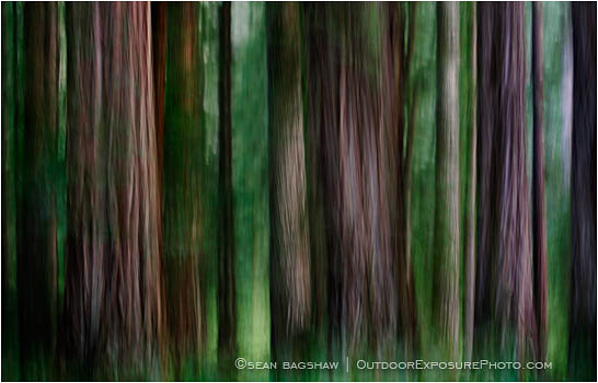
redwood grove

William Neil has been working on a series for the past couple of years he calls “Impressions of Light” or something like that. He is trying to create unusual, impressionistic and intriguing visions of common outdoor photography subjects, something I’m also interested in. He uses a variety of camera techniques, one of which being slow shutter speed panning and/or zooming. A couple months back he had an amazing image in Outdoor Photographer that he took in a Yosemite redwood grove. It really struck a chord with me. This is my own attempt at something similar. It falls far short of Neil’s, but I like how the motion blur smooths out much of the distracting background forest clutter while emphasizing the lines, texture and lighting of the trees themselves. All the blur is in camera. In Photoshop I created several layers that were copies of the background image and then experimented with different combinations of blending modes (multiply, overlay, soft light) to increase color density, contrast and general mood.

Filed Under: Featured Photo Tagged With: fine art photography, Photography Prints, photography technique, Redwood Forest Photography, Redwood Trees, southern oregon photographer, southern oregon photography, William Neil

© 2026 · Sean Bagshaw Outdoor Exposure Photography